|
| Return to Orkneyjar | Introduction | Latest News | Excavation Diary | Excavation Background | Archive Stories |
|
Tuesday, July 29, 2008
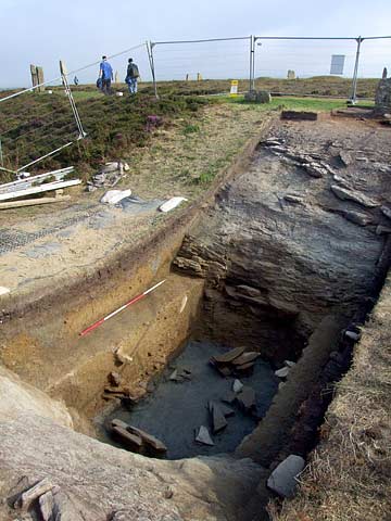
Well, yesterday we finally completed the excavation of the larger northern ditch trench. In all honesty it looked absolutely spectacular. It certainly took us a lot of time and energy simply removing its soft silts and fill. Completely rock-cut, the ditch in this sector is deep, very broad and flat-bottomed. Working at its base makes you realise just how impressive this monument must have appeared when it was first excavated back in the third millennium BC. Similarly, you appreciate the sheer scale of labour that was involved in cutting through the rock to form the ditch, let alone in quarrying and moving the stones forming the circle. The colours of rock have been influenced by water logging so the orange brown Orkney flagstones gives way to a deep grey-blue near the base of the ditch. Strangely enough this actually gives the appearance of water standing in the ditch bottom. From this evidence it is quite clear that in the northern area, at least, standing water collected soon after the ditch was dug. This may seem strange, but it is worth remembering that the surrounding ditch was cut to enclose the area of the stone circle and in the Orcadian island world water surrounded islands and people. Therefore, the use of water to create a division – to separate it from the rest of the world – was an appropriate strategy employing everyday imagery. The great feat of labour employed in the digging of the ditch, albeit in segments or sections, provides some insight into just how important this separation was to Neolithic people. Because it is such a striking monument, a common question that is asked of the Ring of Brodgar is ‘what was it for’ – I think the actual construction process is the key to understanding the monument and the labour mobilised. However, in terms of architecture, the circle may not have been the most significant point in the landscape. With its opposed entrances, the circle may have been built around a pre-existing pathway and passing through it may have altered a persons state – a bit like entering a church and moving towards the alter. In this case the end point of the journey may have been further along the ness of Brodgar. Today we were visited by Peter Yeoman and Trisher Weeks of Historic Scotland. They are very enthusiastic about our work and finding out more about the Ring of Brodgar. Indeed, they have both been great in working hard to set up the project and its excellent that they will see the ditch in its current colourful state! Colin Richards |